


AviNavi, navigation for pilots

คำอธิบายของAviNavi, navigation for pilots
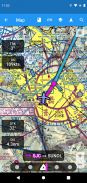
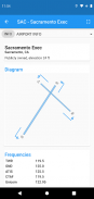
การนำทางการบินทำได้ง่ายและราคาไม่แพง แผนภูมิ VFR, IFR ระดับความสูงต่ำและเครื่องมือวัดสำหรับทวีปสหรัฐอเมริกา พร้อมการวางแผนการบินเต็มรูปแบบ รวมถึงการรองรับการนำทางทางเดินหายใจ โอเวอร์เลย์สำหรับ Nexrad, METAR และ AIRMETS/SIGMETS ปรับปรุงความปลอดภัยในการบิน และข้อมูลสนามบินโดยละเอียด (รันเวย์ ความถี่ เชื้อเพลิง สภาพอากาศ) อยู่แค่เพียงปลายนิ้วสัมผัส
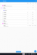
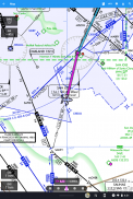
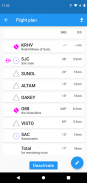
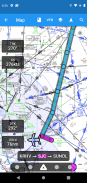
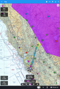
ใช้แผนที่เคลื่อนที่เพื่อค้นหาหรือเลือกสนามบิน, VOR, NDB หรือสี่แยก และเริ่มการนำทางโดยตรง หรือเพิ่มในแผนการบิน หรือป้อนแผนเที่ยวบินในข้อความ เช่น KPAO SUNOL V334 SAC KSAC จะโหลดแผนการบินฉบับสมบูรณ์ รวมถึงจุดนำทางทางเดินหายใจทั้งหมด
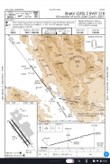
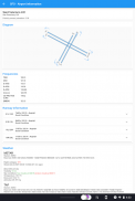
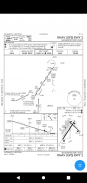
แผนภูมิวิธีการใช้เครื่องมือรวมถึงแผนภาพสนามบิน STARS DPs และค่าต่ำสุด ตลอดจนคำอธิบาย
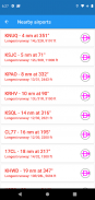
สนามบินใกล้เคียงจะแสดงเป็นสีเขียวหรือสีแดงเพื่อระบุว่าสนามบินเหล่านั้นสามารถเข้าถึงได้โดยปราศจากลมหรือไม่
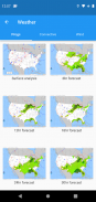
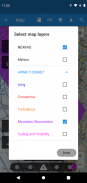
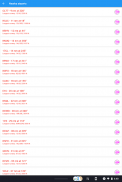
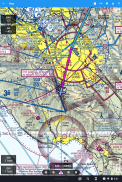
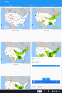
METAR, TAF, AIRMET, SIGMET, แผนภูมิ Prog, Convective Outlook และ Wind พร้อมใช้งานในรูปแบบข้อมูลกราฟิกและ/หรือข้อความ METAR และ AIRMETS/SIGMETS สามารถซ้อนทับบนแผนที่ได้โดยใช้ปุ่มเลเยอร์ ข้อมูลสนามบินแสดง METAR และ TAF เป็นภาษาอังกฤษธรรมดา และแผนภูมิ Prog, Convective Outlook และ Wind สำหรับเวลาและระดับความสูงต่างๆ จะพร้อมใช้งานเป็นกราฟิกแบบเต็มหน้าจอ
AviNavi ต้องการการสมัครสมาชิกรายเดือนหรือรายปีหลังจากช่วงทดลองใช้ฟรี
AviNavi, navigation for pilots--เวอร์ชั่น4.5.7
(08-01-2024)
AviNavi, navigation for pilots - ข้อมูล APK
เวอร์ชั่น APK: 4.5.7แพ็คเกจ: com.bbflight.avinaviเวอร์ชั่นล่าสุดของAviNavi, navigation for pilots
เวอร์ชั่นอื่น


แอปในประเภทเดียวกัน

คุณอาจจะชอบ...


